Where can the tet site be found?
The test site is 200 metres long and is located under the U1 viaduct along Skalitzer Strasse between Kottbusser Tor and Görlitzer Bahnhof, between the intersections with Mariannenstrasse and Manteuffelstrasse.
When will the test site open?
Construction work has been underway under the viaduct since November 2023. The conversion of car parking spaces into a new urban space with lighting, greenery and new street furniture is in full swing. In spring 2024, the test track will be opened and revitalised through a series of events and participatory activities.
Test Site
Reality Check
Between Görlitzer Bahnhof and Kottbusser Tor, we will take the Radbahn concept to the streets and let it prove itself in the real world.

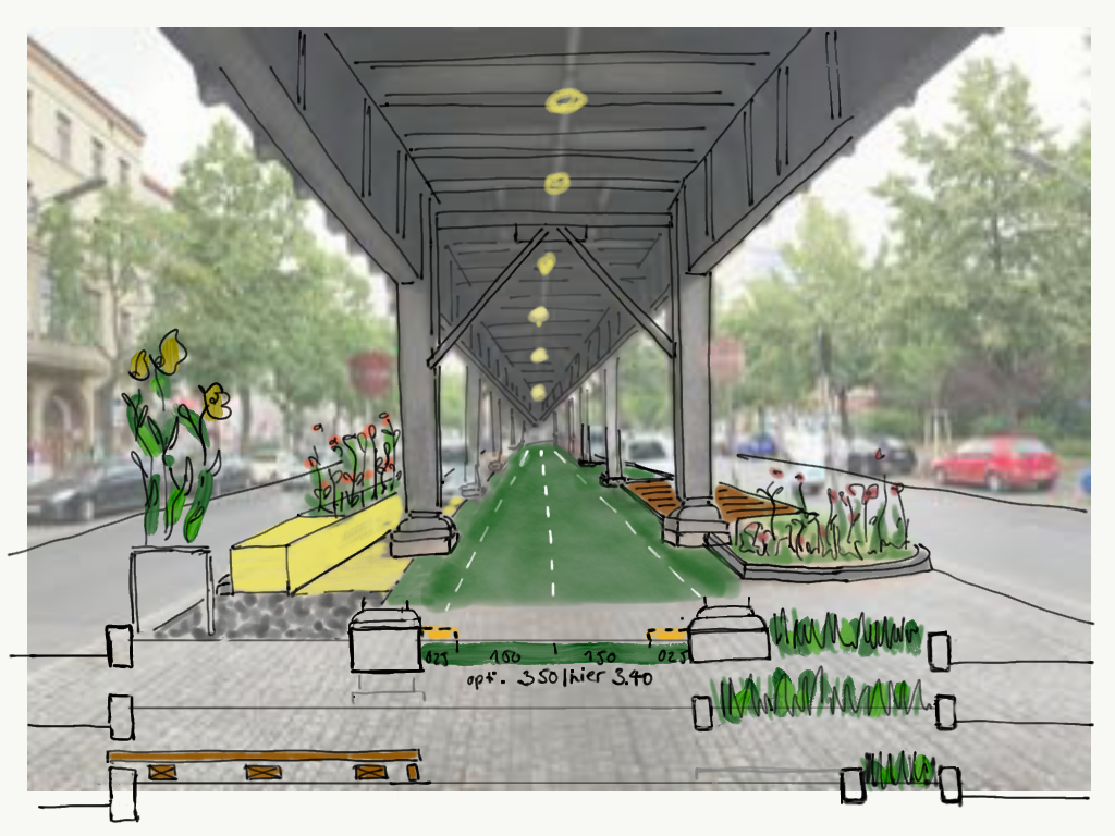
In close cooperation with the district of Friedrichshain-Kreuzberg, a 200-meter-long test area is being built under and alongside the elevated railway viaduct. This will allow us to test the viability of a cycling path in the center of the road across the Skalitzer Strasse/Mariannenstrasse intersection, as well as the on- and off-ramps at the Görlitzer Bahnhof and Kottbusser Tor subway stations.
Timeline until implementation
Traffic planning
Unfortunately, the planned implementation of the neighbouring Skalitzer Straße/Mariannenstraße junction cannot take place at the same time as the test site.
A traffic plan has been drawn up by a traffic planning office and submitted to the Senate Department for the Environment, Mobility, Transport and Climate Protection (SenUMVK) for review in 2021.
Urban planning
The redesign of the area under the viaduct combines the results of our urban planning potential and risk analysis and the results of the public participation process.
Public participation process
Together with our landscape planners Fabulism + Lysann Schmidt and other cooperation partners, we have further developed the test site under the viaduct as an experimental laboratory that combines many topics: mobility, water management, greenery as a contribution to the microclimate, unsealing and the reuse of existing materials. In general, this space can be used by everyone for different activities; we want to know what it is best suited for.
We see the test site as a participatory, experiential space
What does the space look like?
The test site will make the project visible and tangible, and enable people to experience how the space under and alongside the elevated viaduct can be redesigned and used as a bike park. Design and usage proposals gathered during the participatory events can be tested, modified and evaluated.

What is well received, what is not?
The idea is not so much to present a 100% finished solution, but rather to open up a dynamically accessible area as a co-designing space. This could also change and develop over the course of the testing months in accordance with feedback and new findings. An evaluation of this test phase will provide a foundation for technical and planning decision-making, including a catalog of criteria for the planning and construction of the entire route and comparable projects.

What will be tested?
In addition to testing the implementation of a centrally positioned bike path from a traffic perspective, the site will also be used to trial various other technical and design solutions. Topics include, for example, barrier-free accessibility in public spaces, the creation of recreational places, flora and fauna concepts in the urban space, how to maintain the heritage-listed viaduct, and waste and maintenance management in public urban spaces. The site will also be used to test various cycling path coatings, types of lighting, signaling technologies, bicycle guidance systems, greenery alongside the path, street furniture and bicycle infrastructure such as parking areas and service stations.
Basic questions for the practical implementation of the test site at street leve
- How can cyclists ride onto and off a bike path located in the center of the road? How can crossings from the center to the side area be realized?
- How can cyclists cross the intersection safely and in as many directions as possible?
- What are the traffic impacts for all intersections and associated traffic?
- What speeds and visual relationships between road users* will be permitted by the structural conditions?
- What are possible conflict situations between cyclists and other road users?
- How can maximum objective safety be achieved?
- What is the subjective feeling of safety when cycling on the route?
- How high is the sense of well-being or stress?
- How do cyclists perceive the route and how do cyclist behaviors differ?

Looking to the future
A particularly challenging planning question is how this previously rather unattractive space can be designed in such a way that it is also accepted in the medium and long term and remains future proof.
How must the space under the viaduct be designed so that it allows opportunities for procedural changes and, if necessary, different groups of users? If possible, and in coordination with the district of Friedrichshain-Kreuzberg, we will therefore also use the test phase to try out different spatial and traffic scenarios.